Posts

Jack Be Nimble

Image
Extreme statistic: The observation on 1/7/18 recorded the 9th consecutive day with a daily low temperature below zero at OSNW3. All-time most since this station's genesis. If there are any questions, comments, or suggestions on the material presented please let me know. Thanks for reading!

The White Hurricane of 1913

Image
I was gifted a book this Christmas. White Hurricane: A Great Lakes November Gale and America's Deadliest Maritime Disaster by David G. Brown. Until this book was in my possession I had not known about this storm. After reading the first couple pages I decided to do a bit of research on my own before reading more. I grabbed the Oshkosh data for this time period, the Archived Daily Weather Maps and a handful of links with published material on the storm. I am anticipating this book being a great read. (Oshkosh November 1913 Climatology) --- (November 7, 1913) (November 8, 1913) (November 9, 1913) (November 10, 1913) (November 11, 1913) --- Links * The “White Hurricane” Storm of November 1913 - A Numerical Model Retrospective (my favorite) * "HELL HATH' NO FURY LIKE A GREAT LAKES FALL STORM" - William R. Deedler * The White Hurricane of 1913 - Google Images * Frozen Fury: The 1913 White Hurricane - Lake Superior Magazine * Remembering t...

2014-15 Winter Divide?

Image
I do this thing that measures the length of a winter season. The criteria is simple and can be found at the link . Each winter is unique. Long, short, divided. 2014-15 is becoming special in it's own way. Earliest divide since 1994-95? If the MaxT is above 32F 12/26 and the snow depth at obs on 12/27 is I have WSD data back through 1990 for Oshkosh/OSNW3. For the summaries please click here . If there are any questions, comments, or suggestions on the material presented please let me know. Thanks for reading!

2014-15 First Day of Winter

Image
The winter of 2014-15 has begun. Winter is officially here, in my backyard. Let me review the the conditions that constitute a winter season. The definition of a Winter Season Duration (WSD) is as follows, and in the case of OSNW3, six(6), is used for "several" consecutive days. First Day of Winter represents a daily max temp equal or below 32°F and a snow depth of 1" or greater for several consecutive days. Last Day of Winter represents a daily max temp equal or above 32°F and a snow depth less than 1" for several consecutive days. ---- The winter of 2014-15 began on Nov 21, 2014. Which is the earliest by 2+ weeks since 2006 . Below is a graphical representation through Dec 9, 2014. Just an FYI. The winter of 2013-14 lasted 109 days, so did the winter of 2012-13. I have WSD data back through 1990 for Oshkosh/OSNW3. For the summaries please click here . If there are any questions, comments, or suggestions on the material presented please let me k...

July Summary

Image
OSNW3 July 2014 Daily Observations (click on graph for the month summary data - it will open a new tab/window) Can you name these clouds? I cannot. #lakewinnebago #neenah #wiwx pic.twitter.com/ToJdaJ4vZR — Josh Herman (@OSNW3) July 9, 2014 Top 10 coolest days in July (image). MaxT and MinT. Most recent cool MaxT Jul-28 2013. #Oshkosh #wiwx pic.twitter.com/l7SOKP0q6N — Josh Herman (@OSNW3) July 11, 2014 It is a special kind of ominous. #lakewinnebago #wiwx pic.twitter.com/x90OpBE4cu — Josh Herman (@OSNW3) July 15, 2014 Sorta fun going back and reading what I wrote during my first July blogging - http://t.co/AnOVUkMvOY - Here's to many more! #Oshkosh #wiwx — Josh Herman (@OSNW3) July 16, 2014 #OSNW3 temp records began Jan 2007. Never has the temp dropped below 50F in July. 2x now in 2014; 49.8F & 49.2F - http://t.co/HFtdYfRbXV — Josh Herman (@OSNW3) July 16, 2014 #OSNW3 has reached 90 degrees this summer. Currently 92.0°F #Osh...

June Summary

Image
OSNW3 June 2014 Daily Observations (click on graph for the month summary data - it will open a new tab/window) #rain #Oshkosh #wiwx https://t.co/avloHIjJ2z — Josh Herman (@OSNW3) June 1, 2014 Found it a bit discouraging that the #OSNW3 #winter snowfall total didn't make the @NWSGreenBay list. pic.twitter.com/8RHNspDG26 — Josh Herman (@OSNW3) June 5, 2014 The sky above #OSNW3 #Oshkosh #wiwx pic.twitter.com/kZV06dyIA4 — Josh Herman (@OSNW3) June 15, 2014 #wiwx soul. @caseykessenich @RoyalStPatricks pic.twitter.com/JK6OdSS4oZ — Josh Herman (@OSNW3) June 19, 2014 It has been a wet decade thus far at #OSNW3 (see charts). #Oshkosh #wiwx http://t.co/QVjEtgsplf pic.twitter.com/gw2F6jKeZD — Josh Herman (@OSNW3) June 22, 2014 1.91" of #rain at #OSNW3 in #Oshkosh #wiwx . Event began at 21:32 and lasted 50-55 minutes. @LukeSampe @NWSGreenBay pic.twitter.com/f5UFYPKPKB — Josh Herman (@OSNW3) June 24, 2014 June 2014 has...

May Summary

Image
OSNW3 May 2014 Daily Observations (click on graph for the month summary data - it will open a new tab/window) #OSNW3 recorded the least amount of days > 60F for Oct-Apr this decade. #Oshkosh #wiwx (more) http://t.co/MMxTNibFud pic.twitter.com/PNeeGosnaV — Josh Herman (@OSNW3) May 4, 2014 I love me some East winds. #waves on my side of #lakewinnebago #wiwx https://t.co/J5oBgkadam — Josh Herman (@OSNW3) May 7, 2014 Mr @hostalover360 , you have seen many of my FOH photos over the years. What happened to those bushes? Are they dead? pic.twitter.com/5p7YCbEVUf — Josh Herman (@OSNW3) May 13, 2014 Those dead bushes bring life to the front yard. pic.twitter.com/EDUJgbuubm — Josh Herman (@OSNW3) May 26, 2014 15 days with pcpn in May at #OSNW3 , but just 0.07" above #Oshkosh average. http://t.co/4Ankd0mbO3 #wiwx pic.twitter.com/QRB8Env2ZX — Josh Herman (@OSNW3) June 1, 2014

April Summary

Image
OSNW3 April 2014 Daily Observations (click on graph for the month summary data - it will open a new tab/window) 109 Days of #winter in 2013-14 (same as 2012-13). #spring officially began at #OSNW3 on Apr 2 - http://t.co/z5ZzNSI45d (new blog post) #wiwx — Josh Herman (@OSNW3) April 3, 2014 Time lapse of yesterday's #snow accumulation and today's melt. The shadow wins the race - http://t.co/UTjDpvvbyB #OSNW3 #Oshkosh #wiwx — Josh Herman (@OSNW3) April 5, 2014 24hr obs ending 7AM today, #OSNW3 recorded a MaxT of 60.2°. First 60+ since 10/13/13. 180 days ago. #Oshkosh #wiwx pic.twitter.com/EfCN6NXbKn — Josh Herman (@OSNW3) April 10, 2014 18 measurable #snow days in April at #OSNW3 since 2007 - http://t.co/tSdo7evcLN #Oshkosh #wiwx (photos & radarloops) pic.twitter.com/3E8gmO5W7P — Josh Herman (@OSNW3) April 11, 2014 Cats and dogs. Watch the area around #OSNW3 succumb to water. #flood #Oshkosh #wiwx - http://t.co/SmchqvchBC ...

OSNW3 - 2013-14 Winter Season Duration - 109 Days

Image
The winter of 2013-14 has come to an end. Spring is officially here, in my backyard. Let me review the the conditions that constitute a winter season. The definition of a Winter Season Duration (WSD) is as follows, and in the case of OSNW3, six(6), is used for "several" consecutive days. First Day of Winter represents a daily max temp equal or below 32°F and a snow depth of 1" or greater for several consecutive days. Last Day of Winter represents a daily max temp equal or above 32°F and a snow depth less than 1" for several consecutive days. ---- The winter of 2013-14 lasted 109 days. It began on Dec 14, 2013 and ended on Apr 1, 2014. Below is a graphical representation. What is locked into memory from last winter? It also lasted 109 days. It began later, ended later and was not persistently cold like this winter. Note the differences between last year (below) and this year (above). While it seems uncommon, we cannot rule out winter making a return thi...

March Summary

Image
OSNW3 March 2014 Daily Observations (click on graph for the month summary data - it will open a new tab/window) I analyzed the top-5, they are legit. Deepest March snow depths in #Oshkosh #wiwx history - http://t.co/067ddRUjfA pic.twitter.com/bSdpFU932r — Josh Herman (@OSNW3) March 7, 2014 Winds pull strands of ice out into Lake Michigan from Washington and Detroit Islands. http://t.co/ZQMWiV9zfY pic.twitter.com/zybXkRgWyK — NASA Earth (@NASA_EO) March 10, 2014 Thanks for the muse @WIBN06 - looks to be sunny and 53F at #OSNW3 . Snow depth was 8" this AM. #Oshkosh #wiwx pic.twitter.com/1PvbfDLufn — Josh Herman (@OSNW3) March 10, 2014 Overnight #OSNW3 recorded a MinT of 34.5F. This is the first time since 12/4/13 that the MinT recorded +32F. 98 days ago. #Oshkosh #wiwx — Josh Herman (@OSNW3) March 11, 2014 A 16" snow depth difference between #OSNW3 and @WIBN06 - https://t.co/PDWexn5inE (it's a map) #wiwx #Oshkosh #Suamico pi...

A Niagara Escarpment Mini Glacier

Image
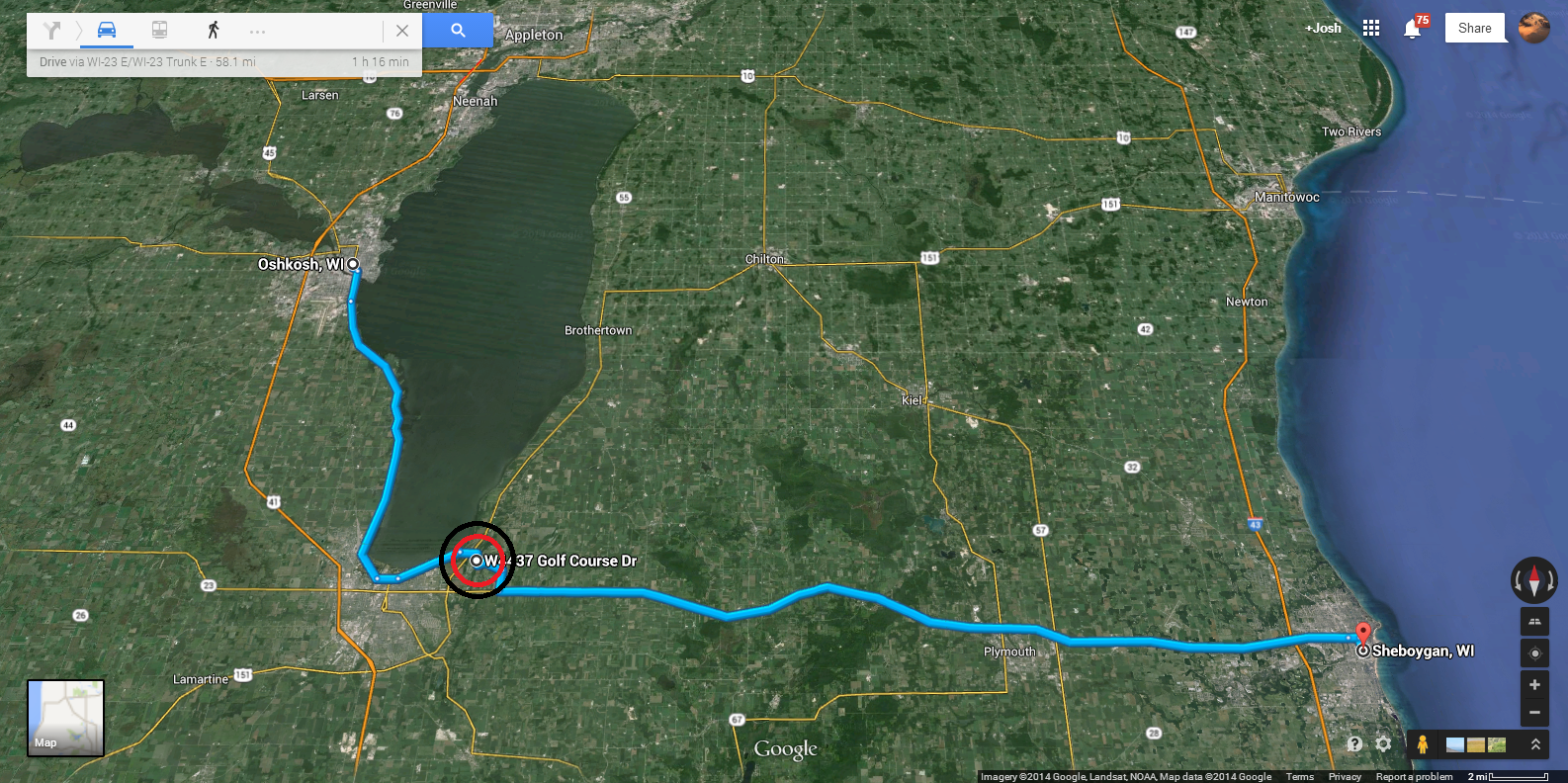
I've been traveling to a customer site in Sheboygan, WI for over a decade. The route I choose to take most often is the road less traveled. I like to go slow and look at the scenery. My favorite portion of the route (the bulls-eye on the map above) is traversing Wisconsin's southern portion of the Niagara Escarpment . During the winter months I often observe a large chunk of ice slowly snaking it's way down the escarpment towards the road. (the bulls-eye on the map below is where the chunk of ice exists) I think of the chunk of ice as a mini glacier. Each time I pass it I notice how it grows, deforms and flows through time. This year is it abnormally large. Compelled by it, I stopped and took a couple photos today. Update on the NEMG - April 1, 2014 While I was on my way out of Sheboygan earlier in the day I hugged Lake Michigan. #lakemichigan is certainly open as of right now. #sheboygan #wiwx pic.twitter.com/R8waQoVNnx — Josh Herman (@OSNW3) ...

February Summary

Image
OSNW3 February 2014 Daily Observations (click on graph for the month summary data - it will open a new tab/window) Sun is shinning and birds are chirping in the backyard. Installing a "sink", "shelves", and a "fireplace" inside the Quinzhee hut. #wiwx — Josh Herman (@OSNW3) February 2, 2014 Awesome what the sun angle can do. Birds everywhere in the backyard. Cardinals, Finchs, Juncos, Chickadees - Spring is in the air. #wiwx — Josh Herman (@OSNW3) February 7, 2014 #EAA skiplane fly-in today! pic.twitter.com/t6GKlQjXnt — Kelly Nelson (@aviatrixk) February 8, 2014 It snowed today. I love snow. 1.6" at #OSNW3 in #Oshkosh #wiwx pic.twitter.com/Ym4hEYCbWe — Josh Herman (@OSNW3) February 13, 2014 Snow has ended at #OSNW3 . Total accumulation of 4.4". Snow depth is 14". #Oshkosh #wiwx @NWSGreenBay pic.twitter.com/YvLITTPPGo — Josh Herman (@OSNW3) February 18, 2014 Saw this on the FB. Ice roads on #B...


January Summary

Image
OSNW3 January 2014 Daily Observations (click on graph for the month summary data - it will open a new tab/window) Mammal acclimation to the change of season is wonderful. A truly balmy 30.9°F currently at #OSNW3 #Oshkosh #wiwx Bring on the cold. #Packers — Josh Herman (@OSNW3) January 4, 2014 -18.7°F at #OSNW3 currently. This marks the coldest reading of the instruments life. #Oshkosh #wiwx — Josh Herman (@OSNW3) January 6, 2014 #lakewinnebago looking southeast. #wendts #wiwx pic.twitter.com/keGERRLSxt — Josh Herman (@OSNW3) January 13, 2014 The little clipper that could. #wiwx pic.twitter.com/yeFLSsimq8 — Josh Herman (@OSNW3) January 14, 2014 Our #quinzeehut #snow pile is gaining girth. A couple more inches of snow and it will be ready to dig into. #wiwx pic.twitter.com/xKjo73ENwt — Josh Herman (@OSNW3) January 15, 2014 Of the 7 recorded days with snow at #OSNW3 this January, only one of them has measured over an inch. http://t.c...

December Summary

Image
OSNW3 December 2013 Daily Observations (click on graph for the month summary data - it will open a new tab/window) I see steam and birds @snowfall4 so I would suspect #lakewinnebago is open just a little way out. #Oshkosh #wiwx pic.twitter.com/toZ9DUCb4S — Josh Herman (@OSNW3) December 6, 2013 Noteworthy. Not often is Winnebago County inside a LES Advisory. Fun. #Oshkosh #wiwx (graphics via @NWSGreenBay ) pic.twitter.com/3xkciaj8Ak — Josh Herman (@OSNW3) December 14, 2013 The view out of my cubical window today. Christmas Monday working. #OSNW3 #Oshkosh #wiwx https://t.co/t9N3bgyWtq — Josh Herman (@OSNW3) December 23, 2013 Shoveled 3x today. Early this AM & twice this afternoon. 2.9" of new fluffy snow today at #OSNW3 in #Oshkosh #wiwx pic.twitter.com/ypYMxjLYt5 — Josh Herman (@OSNW3) December 24, 2013 The observation this AM marks the 7th consecutive day with measurable snow at #OSNW3 . #Oshkosh #wiwx pic.twitter.com/misyO0bN1s...

Winter Storm Warning - Dec 21-22

Image
The National Weather Service in Green Bay has issued a Winter Storm Warning for the area. It's the first of the season. We will be watching it's progress through our backyard with due diligence (an act with a certain standard of care). Enjoy and be safe. ---- Measurements (4) ---- Dec 23, 2013 @ 07:25 It snowed lightly through the day and night after the 12:05 observation. That usually happens on the back side of these kind of systems. 1.2" - New Snow 4.9" - Total Storm Snow Current Snow Depth - 6" (Dec 23, 2013 - 07:25 - 1.2") ---- Dec 22, 2013 @ 12:05 I would not consider this a "snow storm" or a need for the advertised Winter Storm Warning. But, whatever, at least it snowed and we got to play in it. The sun is out and the snow is sparkly. Go Packers! 0.6" - New Snow 3.7" - Total Storm Snow Current Snow Depth - 5" (Dec 22, 2013 - 12:05 - 0.6") The #wovel uses half the time and half the effort ...

November Summary

Image
OSNW3 November 2013 Daily Observations (click on graph for the month summary data - it will open a new tab/window) #OSNW3 ends November -3.1°F and +0.87" of #Oshkosh 30yr avg. http://t.co/QdNz0aomfi http://t.co/UsRyHmbvYr #wiwx pic.twitter.com/1ocm9lzdqS — Josh Herman (@OSNW3) November 30, 2013 Through the 11th month of the year, #OSNW3 is +6.15" of the #Oshkosh 30yr annual precipitation average. #wiwx pic.twitter.com/OvWyBrw2nZ — Josh Herman (@OSNW3) November 30, 2013 More typical to see 270 navigable days on Lake Winnebago in the last decade, only 224 this year, late thaw and early freeze — Clint Harness (@snowfall4) November 29, 2013 Yesterday #OSNW3 recorded it's coldest day since Mar 21-22, 2012 (18.8°F/9.3°F) - Daily climo at link http://t.co/QdNz0aomfi #Oshkosh #wiwx — Josh Herman (@OSNW3) November 24, 2013 #OSNW3 recorded the first #snow accumulation (0.5") of the season this AM. #Oshkosh #wiwx pic.twitter.com...

2013-14 First Measurable Snow

Image
We recorded our first measurable snow the morning of Nov 22nd. Based on NWS GreenBay NOWData (81-10), Oshkosh's first measurable snow occurs on Nov 26th. Based on OSNW3 data since 2006 , it occurs on the 324th day of the year, which is Nov 19-20th.

Oshkosh 2013-14 Winter Forecast

Image
The 2013-14 winter forecast for Oshkosh is based on organic forecasting techniques. More details on the techniques are located in another  blog entry  (click the link to read more). I am going to make this forecast short and sweet and let the data do most of the talking. There are a few items that are new to my model this year and more info on them can be found in this blog entry  (click the link to read more). Temperatures will likely end near average, but I need to mention this average is misleading. There will be many ups and downs along the way, shots of seasonal warm and cool air, just like most winters in WI. Snowfall will likely be above average. There are 20 inches of snow separating ensemble members currently, M2 sees 38.5 inches while M3 sees 58.0 inches. OSNW3|WxClimate - Oshkosh Forecast Trend The image above is a snap shot in time. I captured the data on 20NOV13. Both temperature and precipitation numbers will evolve as the seasons progress so  c...

October Summary

Image
OSNW3 October 2013 Daily Observations (click on graph for the month summary data - it will open a new tab/window) #OSNW3 ends October -0.6°F and +0.94" of #Oshkosh avg. http://t.co/qlRmFFVAxm http://t.co/2fqV9S5GeO #wiwx pic.twitter.com/fyhWkZhVmP — Josh Herman (@OSNW3) October 31, 2013 My @WPSstorm bill this month is the lowest it's been for an October bill since 2006 when it was the same, $77. #wiwx — Josh Herman (@OSNW3) October 29, 2013 Looking east. It was #sleeting as I took the photo. #lakewinnebago #clouds #wiwx pic.twitter.com/51JPx4dChC — Josh Herman (@OSNW3) October 21, 2013 #autumn at @WIBN06 pic.twitter.com/GTHghRmkz1 — Josh Herman (@OSNW3) October 19, 2013 Prior peak? Peaking? Past peak? #autumn #Neenah #wiwx pic.twitter.com/eXqvJMrzFe — Josh Herman (@OSNW3) October 14, 2013 #lakemichigan #sheboygan #wiwx https://t.co/EH1HTavwXx — Josh Herman (@OSNW3) October 11, 2013

First Wind & Waves of 2013

Image
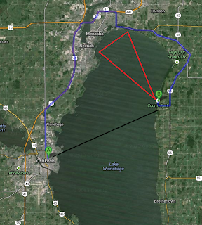
On Saturday October 26th my daughter and I ventured to Calumet County Park . County Park is located almost directly across Lake Winnebago from Oshkosh. About 12 miles as the crow flies and 35 miles by northern road access. Upon arrival, traveling down the Niagara Escarpment , we were witness to an excited Lake Winnebago. Forecast from the NWS Green Bay foretold winds of 15-20 knots and waves of 3-4 feet. This forecast would verify. The sights and sounds were just what we were looking for. Colorful trees whipping wildly with the constant roar of the wind and crashing waves. And of course the playground set. We also witnessed a smoke plume off in the distance towards the northwest depicted in the map above by an approximate red triangle and in the image below by a red circle. It appeared something was burning in East central Calumet County at 2:30 this afternoon, the smoke plume was visible from Neenah. — Clint Harness (@snowfall4) October 26, 2013 Below is a short vid...