Posts

Showing posts from October, 2011

Autumn Has Taken Hold

Image
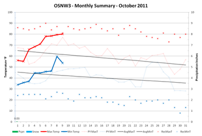
The cool and crisp feeling of Autumn is finally being felt here at OSNW3. It took a while. We have yet to dip below the freezing mark, however. Fairly soon though we will be adding the 2011 date to the Winter History page. ( **First Freeze took place on Oct-28 ) The later it comes, the better in my opinion. Only because recent climate trends show more snow falls in winter when the first cold blast takes place a couple weeks later than average. The average first freeze in Oshkosh is Oct 12 (1981-2010). This year has more climatological posibility since it is another La Nina year. A comparison for Oshkosh winters during La Nina is below. "For the second winter in a row, La NiƱa will influence weather patterns across the country, but as usual, it’s not the only climate factor at play. The ‘wild card’ is the lesser-known and less predictable Arctic Oscillation that could produce dramatic short-term swings in temperatures this winter." Read more here . With that said...
Serotonin Overload?

Image
Perhaps. I've got a few cognitive symptoms: agitation (seasonal allergies), hypomania (feels like I am on the 'summer' schedule yet), mental confusion (it's autumn, right?), hallucinations (thought that was a cloud, nope, just contrails). But seriously, we haven't had a cloudy day in quite some time. As a matter of fact the first 216 hours or so of October sky observation have been mainly clear. No quantitative numbers for this statement, just my gut feel. Some numbers that are real however are the ones that describe our lack of precipitation. Only three hundredths of an inch have fallen in October and we are on pace once again to crack the top five longest dry spells at OSNW3 . With the new LRC forming we are forced to follow the computer models for a long range query. The CPC predicts a continuation of above average temperature and below average precipitation. Similar to last year at this time. In the short term however, expect a cool down with chances o...

Winds & Waves - Door County, WI

Image
Discussions during the days leading up to Sep 30 revolved around forecasts for central and eastern south shores of Lake Superior being targeted for extreme winds and waves and the idea that I planned to visit Marquette, MI to capture as much of the event as I could. Turns out the time I had available wasn't enough for a trip to the UP. Instead I choose to take a trip to the Door County Peninsula. (My route to Door County) My initial thoughts were to adventure along the Peninsula State Park shoreline but when I arrived the park was closed and was to remain closed until further notice. My plan was derailed but the Door County Peninsula never disappoints if one is patient in finding the right spot. I continued north through Sister Bay, Ellison Bay and Gills Rock for a final destination of Kenosha Park, the very top of the Peninsula. This wind event left many roads throughout Door County impassable and many residents and businesses powerless from Carlsville to F...